PARIS, 27-29 April 2026
Paris International Conference
International Conference

Day 1 – From Policy to Practice: Keynotes on the Future of GEO Education
The conference opens on Monday, 27 April 2026 with a series of keynote talks and project results and presentation that set the scene for GEO‑Academy’s mission and impact. Keynotes include the project presentation, its importance, and policy insights on future educational competencies.
Day 2 – From Practice to Impact: GEO‑Academy Teaching, Reflection and Innovation
On Tuesday, 28 April 2026, the focus shifts to practical teaching and peer‑learning. Teachers share best practices through dedicated presentation sessions, posters and roundtables that address professional development, curriculum integration, sustainability, and challenges in implementing geospatial education. This day emphasizes reflection on real classroom use of training materials and collaborative innovation among participants.
Across these two days, the conference offers a mix of keynotes, panel discussions, teacher presentations, and interactive roundtables designed to showcase the GEO‑Academy’s work and its contribution to sustainable education.
Call for Posters and Abstacts
We invite teachers, educators, and education professionals to submit abstracts by 27 February 2026. Contributions will be presented as posters, to be submitted by 10 March 2026, exploring the question: How have you applied, or how could you apply, GEO-Academy and GEOBSERVE in your teaching practices?
Submissions may focus on implemented practices, innovative pedagogical approaches, curriculum design, or prospective applications, even if they have not yet been fully implemented. This call welcomes both practical experiences and well-structured proposals for future classroom integration.
Paper presentations may include empirical or theoretical studies, reviews of existing practices, comprehensive case studies, analyses of policy or curricula, and presentations of conclusive project outcomes.
Poster submissions are encouraged and can highlight pilot activities, prototypes, ongoing projects, practical lesson ideas, exercises, or visual summaries of classroom experiments.
Posters provide an opportunity to present innovative ideas in a concise and visual format and will be displayed during dedicated poster sessions at the conference.
Abstracts should be no longer than 2,000 characters and must be carefully composed and thoroughly checked, particularly regarding the list of authors, to avoid last-minute changes. Authors are required to use the official abstract template.
Submission
- All abstracts and inquiries should be submitted by email to shana.sonntag@eurisy.eu
- Email subject: Submission of paper and poster
- The submission of an abstract and poster implies the commitment that, if accepted, the contribution will be presented at the International Teachers Conference in Paris the 27-28-29 April 2026 by the corresponding author or, at minimum, by one of the co-authors.
- Authors will be notified of acceptance by 15 March 2026 English is the official language of the conference.
- For each accepted contribution, at least one author must register for the International Teachers Conference in Paris on 28 to 29 April 2026 within the specified deadlines; failure to do so may result in exclusion from the proceedings and the withdrawal of the accepted contribution. Abstracts and posters should include the title, list of authors and affiliations, background and objectives, description of the teaching activity, project, or proposal, expected outcomes or preliminary results, and the relevance to GEO-Academy and GEOBSERVE.
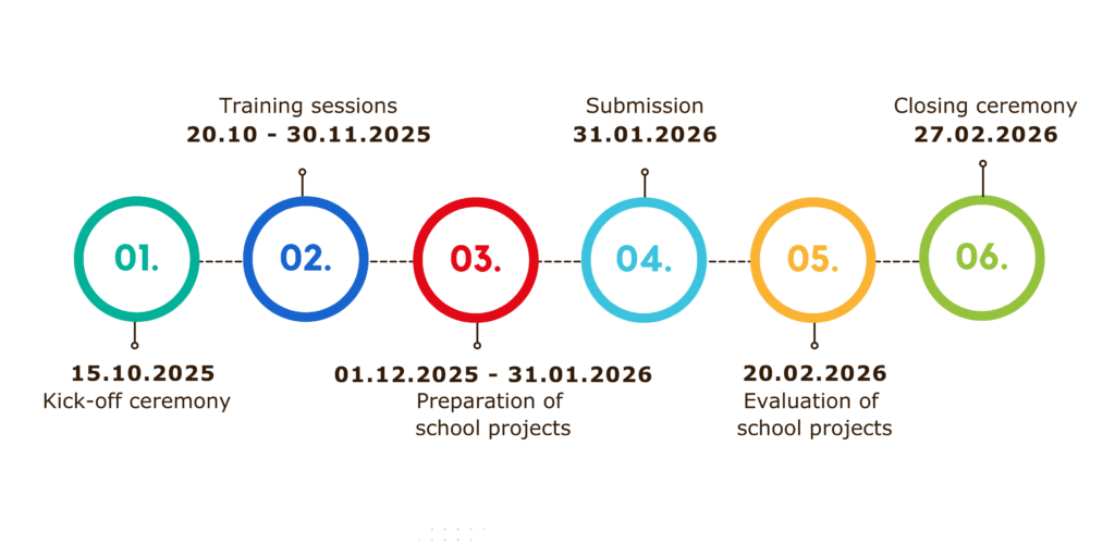
Important Dates
26 January 2026 – Registration and submissions opens
27 February 2026 – Submission close, deadline for abstract submissions
15 March 2026 – Notification of acceptance
30 March 2026 – Presenter registration closes
28 April 2026 – Presentation of the Paper

The Organizers - GeoAcademy Project
The GEO-Academy is an Erasmus+ funded project that aims to enhance teachers’ digital, green, and spatial skills for sustainable development education. It establishes a European network of educators, providing training and innovative digital tools focused on geospatial technologies like GIS, Remote Sensing, and Earth Observation. Through national GEO-Hubs and the online GEOBSERVE platform, the project offers professional development for teachers to integrate these technologies into their classrooms and effectively teach the UN Sustainable Development Goals, as well as to deliver innovative lessons on topics such as climate change, environmental monitoring, and geographic information systems (GIS).
Framework
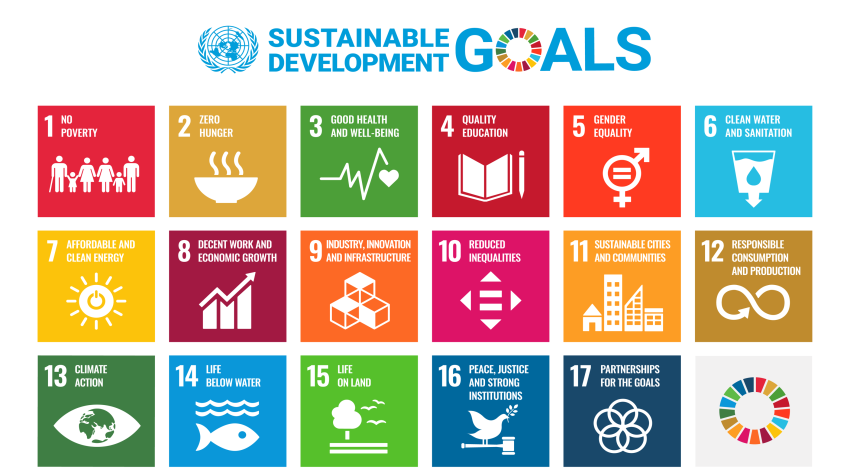
The Sustainable Development Goals (SDGs) established by the United Nations are a comprehensive guide for addressing emerging challenges- social, environmental and economic- both in developing and developed countries, in order to make the world more sustainable for future generations. They are not just goals to be achieved; they are the means to make a lasting sustainable and peaceful future. Given that this vision is globally common, it is essential that younger generations are able to understand and contribute to their fulfilment.
Scope
The Competition aims at raising awareness among the school community about the SDGs by utilising geospatial data, new technologies, digital maps, and geospatial storytelling.
With the support of their teachers, students are invited to select and explore a SDG-related topic, presenting their findings creatively and illustratively through a digital geospatial narrative (storymap).
Here some indicative examples of SDG-related topics within our school and our local community:
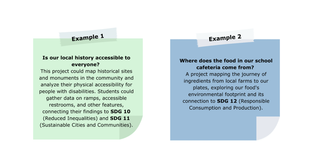
Of course, every school is free to choose any SDG-related topic they wish to study.
Through their participation, students will strengthen their spatial thinking and digital skills. Additionally, through experiential and inquiry-based learning processes, accompanied by awareness-raising actions organised by the schools, students will become familiar with the SDGs and gain a deeper understanding of the Goals.
The technological tools used will be provided free of charge to schools upon request.
Entries submitted to the Competition will be evaluated by a special Scientific Committee, which will be announced in due course.
Why to participate?
- Learn and better understand the 17 UN Sustainable Development Goals
- Explore and practically apply geospatial concepts, technologies and applications
- Create digital maps and engaging geo-narratives (storymaps),
- Enhance spatial thinking and digital skills
- Access modern educational material validated by the GEO-Academy Universities and partner educational institutions
- Explore and raise awareness on global challenges linked to the environment, society and sustainable development.
Who can participate?
Teachers and students from the 5th and 6th grades of Primary schools, Secondary and High schools in Europe
Language: English
How to participate?
- Fill-in participation form
- Enrol to the Map Storytelling course in the GEOBSERVE platform for the training courses
- Obtain educational licence of ArcGIS (free of charge upon school request – instructions will be sent after submission of participation form)
- Choose and study at least one topic related to SDGs
- Students and teachers prepare the school project and submit the final Storymap
- Submitt your story (details to be announced)
Evaluation Criteria
- Compatibility with the Competition’s theme: The content of the school project should align with the topic of the Competition, as described in the relevant announcement (20% [0-20 grades])
- Coherence: Design, implementation, appropriate structure, flow, coherence, so as to clearly present the concept and content of the project (20% [0-20 grades]).
- Utilization of technological means: Effective use of the capabilities of technological tools (e.g., maps, sound, video, images, etc.) (20% [0-20 grades]).
- Completeness: Comprehensive presentation of the topic and openness of the project towards society through relevant collaborations (e.g., interviews, actions, additional material for a broader presentation of the topic, etc.) (20% [0-20 grades]).
Creativity and Innovation: Overall aesthetic of the project, creativity, originality of approach, innovative elements and ideas (20% [0-20 grades])
The Organizers – GeoAcademy Project
The GEO-Academy is an Erasmus+ funded project that aims to enhance teachers’ digital, green, and spatial skills for sustainable development education. It establishes a European network of educators, providing training and innovative digital tools focused on geospatial technologies like GIS, Remote Sensing, and Earth Observation. Through national GEO-Hubs and the online GEOBSERVE platform, the project offers professional development for teachers to integrate these technologies into their classrooms and teach the UN Sustainable Development Goals effectively